
OPENING QUESTIONS: Contrast the 5 ocean wave characteristics of a tsunami in the deep open ocean with those of the same wave as it approaches the shore.
LEARNING TARGET: I will be able to analyze specific tsunami graph data during today's class.
WORDS O' THE DAY:
- frequency (waves/second or waves/minute)
- period ("seconds/wave or minutes/wave")
- amplitude (wave height)
- wavelength (distance from crest to crest)
- crest (the highest point of the wave)
- trough (the lowest point of the wave)
- speed = (wavelength x frequency. NOTE: (meters/
wave) x (waves/sec) = meters/sec - Tectonic Plate
- Earthquake Magnitude
- tsunami (a water wave typically caused by earthquakes and landslides)
- Subduction Zone
CALENDAR: Watch for Observations This Week!
WORK O' THE DAY:
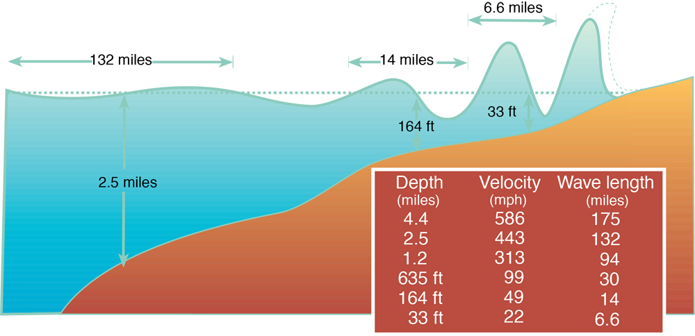
Tsunami Wave Characteristics:
The wave characteristics of an ocean-wide tsunami change *drastically* based on the ocean depth and contours of the ocean bottom (topography).
You don't have to know all the numbers on the chart below but you MUST be able to compare & contrast the wave characteristics of an ocean-wide tsunami in the deep open ocean (velocity = jet speed, wavelength = hundreds of kilometers etc...) with those same wave characteristics as the tsunami approaches the shore (increased amplitude, lower speed, smaller <<but still substantial>> wavelengths etc...)
The massive 9.5 magnitude earthquake in Chile occurred on May 22, 1960, near the city of Valdivia, in southern Chile at 3:11PM (Local Time).
Below is the NOAA tsunami map for that event. I have cropped it to make it easier to view. You can click on the image itself to see an even larger version:
- What was the wave height as the tsunami approached Hilo Bay?
- How long did it take the wave to reach Japan?
- Why didn't the tsunami wave height remain constant as it spread out over the Pacific Ocean
- How long did it take for the wave to hit Cape Town, South Africa and what was its amplitude when it arrived there?
- How is it possible to measure a small amplitude tsunami wave amid the chaotic motion of the ocean? (in otherwords, image you are in a small boat a hundred meters or so off the beach and you see small little ocean waves near the shore, larger waves breaking off shore, tides and currents and yet among all of that we can somehow measure <<quite accurately>> such a small amplitude tsunami wave!)
Here is an interesting account of the tsunami that inn undated large parts of the city of Hilo in 1960.
What characteristics of the ocean bottom as well as Hilo Bay AND the City of Hilo itself contributed to the severity of that damage?
Please discuss.
We often think of "a" tsunami wave (singular). That's because there is typically one wave that has a higher amplitude than other waves in the tsunami 'train'.
As you can see from the graph below, that is not usually the case:

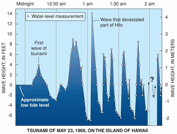
Let's continue with the analysis I introduced at the close of class yesterday:
-
Work with your team to determine the 5 wave characteristics of tsunami as it came ashore in Hilo Bay. Notice that this is real-world data. As such it is typically not all nice and well behaved like classroom graphs. You will need to make allowances for that.
-
Also, please determine the average velocity of that wave as it raced from Chile to Hilo Bay.